Inflatable Canoeing Adventures - Buy this eBook!

Most of us can relate to the fun we had canoeing at summer camp when we were young. But that was nothing compared to the experience of whitewater kayaking that came next for me. I have always loved canoeing, though it always seemed difficult to participate. It has only been in the last decade that the development of inflatable canoes has made a big difference. You can more easily access rivers, you can store a canoe in your car, you can even take them on a plane. They are very light, very cheap, with little loss of functionality. Perfect for weekends away or campervan holidays. Social networking was the other big change. You can now use Facebook, etc to join canoeing adventures in your local region or abroad.

Inflatable Canoeing Adventures - view the table of contents! Click here to download the table of contents for this eBook, available for just $US7.95.

Thursday, March 11, 2010

Safety on the river

Inflatable canoeing I would suggest is safer than other forms of canoeing for a number of reasons, though the risks of rivers should never be under-stated. This accident report pertaining to the death of an 18 year old girl on a NZ grade 2 river highlights the negative perception attached to rivers. There are several important facets to safety on the river:
1. Awareness of river conditions - Research is required before entering a river. Most Western countries have a canoe guide, i.e. Whitewater NZ is available in most NZ libraries. Similar guides are available in other countries or states.
2. Awareness of river hazards - do you know where the difficult rapids are? Do you know the latest warnings? Has the river been in flood, perhaps presenting new risks after boulders or logs have moved? If you are unsure of how rivers work, you are less likely to anticipate risks.
3. Awareness of how river hazards or risk vulnerability can change - The river is a dynamic system; it is always changing. The changes can be gradual (as under normal water flow) or rapid (as in cases of flood), so if you are considering canoeing after a long time or after flood, you should consult local canoe groups, or scout rapids for risks.
4. Preparedness for conditions - Has there been a river flood lately? Do you know the river height, and how changes in river height impact the river.
5. Support in case of mishap - good if you have a cell phone or ready access to a road

Please read the following accident report to acquaint yourself with some of the risks of canoeing. On a positive note, some of the benefits of inflatables are:
1. A non-fixed canoe means there is more leeway for a person to escape if you are trapped between a canoe and a hard place, as an inflatable is less likely to deflate quickly
2. A non-fixed canoe is light so you are less likely to fall over and injury yourself, i.e. If you are portaging around a rapid or to/from the river.
3. A non-fixed canoe is far more comfortable to sit in because it is an air cushion offering you a greater range of seating or lying positions.

On the negative side:
1. Inflatables need to be pumped up - this can be exhausting if you are in a hurry or unfit. On one occasion my hand pump was wet, so it was very difficult to pump. There was resistance in the up and down stroke which made pumping tiresome. So avoid getting your hand pump wet. The other option is to use a foot pump or a car based unit.
2. Inflatables exposure your butt to the 'hardness' of rocks. If there is a very sharp protruding object like glass, street wire (protruding from concrete foundations perhaps), you are more exposed. I have hit rocks with enough force to feel a rock. In the canoe you have two layers of defence - the air chambers in the base of the canoe, and the air chambers of the air seat cushion. I have felt rocks barely though these layers of cushioning, so ensure you have adequate air pressure. I carry a pump on the river and pump up the canoe if I am waiting for others. It takes no time at all.
---------------------------------------------
Andrew Sheldon www.sheldonthinks.com

Biosecurity threat posed by inflatable canoes

Biosecurity warning for inflatable canoe users. Inflatable canoes are an excellent means by which to enjoy a river. They are particularly useful for recreational users or 'explorers' like myself who like the idea of pulling out a canoe from the car and running the river.
This convenience however should not discourage people from being responsible. Inflatables are a potential biosecurity hazard if they are not properly cleaned. Recreational canoeing poses a threat to wildlife is a canoe is taken from one river (region) to another, and more particular from one country to another.
In NZ there is currently no didymo in the North Island rivers, though the first occurrence was reported in the South Island rivers in 2004. The sad reality is that recreational fishermen and canoeing enthusiasts are leading the efforts to protect rivers. The flipside is the risk they pose to these rivers. I would suggest that inflatable canoes pose a particular risk.
When a fisherman stows his gear is is likely to dry out so the didymo is likely to die. A canoeist is similarly likely to dry out their wetsuit and other clothes, if not wash them. The prospect of spreading didymo is increased by inflatable canoes because:
1. The waterproof plastic can trap pockets of didymo (algae) laden water in the folds of the canoe
2. The waterproof plastic prevents evaporation and drying of the canoe

For more information on didymo in NZ refer to this brochure. Similar precautions should be taken in Australia and other countries. Island nations like Australia and NZ have for a long time been safe from such scourges. It would be nice to preserve them.

It is very easy to clean an inflatable. Simply follow the following steps:
1. Deflate or inflate the different pockets/compartments of the canoe away from the river
2. Wipe down the canoe with a dry cloth before and after your canoeing experience
3. Fold or unfold the canoe away form the river
4. Identify any water within the canoe and dry - both when stowing and unstowing your inflatable
5. After your canoe trip ensure you leave the inflatable to dry in the sun. I would suggest drying in a way which allows all water to drain out. After most water drains, after 30 minutes move the canoe to avoid water accumulation. You can do this at the river or at home for convenience.
6. Wash and dry the rag that you have used to clean the canoe
7. Remove any sendiment or leaf little that might accumulate in the inflatable.

The problem I have with this Didymo Awareness campaign to protect NZ rivers has been conducted is the lack of information in this brochure about cleaning your equipment, cand the lack of email contact info if you have questions, etc. Not everyone lives in the area. Travellers from overseas might want more information. After all this algae was spread to NZ by either Europeans visiting or NZ'ers returning home after a canoe or fishing trip in Europe.

These risks may apply to any river or country so its important to be aware of the general risks of using inflatables.
----------------------------------------------
Andrew Sheldon www.sheldonthinks.com

Thursday, March 04, 2010

Canoeing the Otaki River, Manuwatu Range, North Island, NZ

The Otaki River (grade II-III) is a lovely scenic river on the North Island of NZ. The river is an excellent introduction to grade 2-3 whitewater, and provides very good access if you need to exit the river prematurely. The river’s rapids are not huge, and are well-spaced for beginners. Some rapids comprise rock gardens, which will not bother the technically -competent canoeist, but otherwise present only a nuisance. Beginners should take care to avoid potential snags, where the river current flows around tight corners; taking the canoeist potentially through trees. It is a small risk for the skilled canoeist.
Otaki township is a good place to meet, as there are several cafes in the centre of town. There is an outdoors-canoe shop opposite two coffee shops. If you are interested, there is a community market every 1st and 3rd Sunday in the month.
The river access is from the south side of the town. Take the exit road East just south of the Otaki River and drive to the ‘Bridgeview’ Bridge. The exit point is right after the Kaitawa Rd turnoff/bridge. This is where you should leave your exit vehicle, as you will need to get back to the point of river entry. I suggest using a GPS waypoint to identify this location on the river, as its easy to miss the exit. If you can identify the bridge, the exit is just 10m from the top of the rapid on the left above the ‘Bridgeview’. Take care on the track up to the road as it is steep. I suggest carrying the canoe on your left shoulder to avoid falling/slipping off the slope/steps.
There are a number of places you can enter the river, as there are a number of bridges crossing the river. Otaki Forks and above presents good entry points. The entry point is actually not on the Otaki River but a tributary. We entered at a campground after a Dept of Conservation (DOC) gate, however this gate is sometimes locked. Regardless, anywhere around here provides a suitable entry. We canoed the river at a river level of 2.1m, though apparently higher water does not make much difference to the water grade, though it is faster. It tends to drown the rock gardens, making it easier to navigate. The rapids are grade 2-3, though they tend to be easy grade 3 because they are discrete rapids, and not particularly difficult technically. i.e. Large standing waves require some good balance.
Once again I used a Sevylor Tahiti inflatable canoe on this river and it was well suited to the conditions. The steep valley walls means that wind does not present a problem. The shallow gravel river also posed no difficulties. I think you could comfortably canoe this section in 2.5 -3 hours. We were in at 10am, and out by 2pm, however we were a large group and people were taking their time, playing in the rapids.
---------------------------------------------
Andrew Sheldon www.sheldonthinks.com

Sunday, February 14, 2010

Inflatable canoeing on the Manuwatu River, NZ

The Manuwatu River cuts its way through the Manuwatu Ranges, immediately NE of Palmerston North, 1 hour from Wanganui. The lower section described provides a suitable place to learn canoeing with instruction. The best support comes from one of the local clubs, or even scout groups for kids.
Entry point: There are two possible entry points.
The 1st entry is along the Masterton-Napier road crosses the river at Ngawarupoa(?). This upper section is grade 1-2, though it hosts a lot of willows, and for that reason good techical skills will be required to canoe this section. Entry to the river is easy because the river is crossed by the public road.
The 2nd entry for the second section starts just above the gorge. Coming from Palmerston North, there is a bridge as you emerge from the gorge, take a track off to the south. This track is through public common area. Drive along the track until you reach the river.

Our group mostly used fixed hull canoes and kayaks, however I was using my inflatable Sevlor Tahiti canoe. This river is not really suitable for inflatables in one respect - it is very windy under most conditions. The Manuwatu Ranges is home to many of NZ's wind farms. For this reason, it is not suitable. Contrary to expectation, the gorge area is not always sheltered from these winds, but can actually act as a conduit for them. If you are using an inflatable I suggest judging whether its better to follow the edge of the river (for shelter) or stay mid-stream to utilise the speed of the current. It is also advisable to use both seats, so your canoe sits lower, or to place a heavy carry bag in the front. Otherwise try to position yourself in the middle. If you sit at the back the front tends to catch in the wind. The more you can distribute your weight along the canoe the better. The less water in your canoe the better, so tip out any water if you stop. There were a few areas where we were fighting winds.

This gorge is not particularly scenic, though it was a good river to introduce my partner to canoeing. It was also a good opportunity to test two canoes that we had bought 2nd hand. Fortunately both worked, except for a slow leak in one compartment. Clearly the previous owner was too lazy to fit it. I have found you get a leak about one-in-ten times I go canoeing, and its easier to fix a leak than portage a fixed hull canoe around a rapid. Try slipping on some rock with a heavy canoe compared to a light air mattress.

If you are interested in learning more about how to canoe with inflatables - we have written an eBook on the topic - Inflatable Canoeing Adventures. We have used these Sevylor inflatables in Japan, NZ and Australia so far. The attraction is the functionality of the canoes, their lightness and compactibility, so you can pack them in the back of a car or even take them on a train, as I did in Japan. I think activity like canoeing adds an extra dimension to a holiday experience. i.e. Like mountain biking across the Himalayas. I'm not writing a book about that though...pity the sucker who does.

The following map provides location guidance.

View Canoeing trips in a larger map
------------------------------------
Andrew Sheldon www.sheldonthinks.com
Wanganui, New Zealand

Tuesday, July 21, 2009

Kayaking the Chico River

Last week we visited the area of Sagada, which hosts some of the Philippines best limestone caves. Actually I did not visit the caves, as I was quite sure they would not be as spectacular as Jenolan Caves, west of Sydney. Anyway, 10km south of Sagada is the town of Sabangan, which lies on the Chico River. The Chico River would have to be one of the better rivers in the Philippines for kayaking. The river has a continuous series of rapidsore interested in the canoeing, so for those who are similarly interested, I am planning a return to the area in May 2010 to kayak this river. The rapids are mostly grade 2-3. I hear there are grade 4-5 rapids, though based on my river observation from the main road, this is more likely the lower section. I only saw the river as far as east as the Sagada turn-off, and it was not suited to rafting (i.e. too narrow, too shallow). The Chico River flows from Mountain Province, a few hundred kilometres north of Manila, but it takes 6 hours alone to drive the 80km section from Baguio-Sagada because although the road is mostly sealed, its VERY windy. Fortunately there were no tricycles in this section.

I would also be worthwhile to take some time to walk along the river from Panorama ParkView to the town of Sabangan. I have no doubt that you should be able to get a tricycle back to your car if you leave your car there, otherwise its a steep walk back to the car. There appears to be a steep alternative exit further back (round trip). I did not do it on this walk, but I would like to return to the area to kayak the river and to walk along the Chico River. The pathway passes along the river through rice terraces.
Increasingly I see that the Dept of Tourism in the Philippines is starting to spend money on worthwhile project as these to boost tourism, and to give visitors something to do. If you are more interested in rafting, there are groups that run rafting trips on the river. I have information on this, or you can inquire at the Rock Inn, in Sagada. This is a fairly nice place to stay. Nice accommodation, though off-season you will have to wait a few hours for a meal as they do down to the markets to buy the food.
If you want to get to this area, I would advice coming in from the Nueva Viscaya province (east side). The road is not as good, but it will be faster, particularly as they are currently upgrading the road - sealing it with concrete. Baguio is a great market to buy food, and there are some good entertainment places there. Many foreigners like living there because its cheaper, cooler, though it is congested because of the mountain topography.
----------------------------------------------
Andrew Sheldon www.sheldonthinks.com

Friday, January 02, 2009

Indonesia - Rafting Adventures

Indonesia would have to be one of the most appealing rafting/canoeing playgrounds in the world if you are looking for exotic holiday adventures. There are a multitude of rivers to choose from. Some are within a few hours drive from Jakarta, though others in the back-blocks of West Kalimantan might take you 3 days to get to. That might sound like a great adventure, but consider the risk if you get injured.
One of the benefits of rafting in Indonesia is that you can run the rivers at any time of year since some rivers are feed by Springs. There are a range of rafting rivers in Indonesia providing trips from an enjoyable few hours in the jungle or rice padies (Bali or Java) to multi-day excursions through pristine jungle (Sulawesi and Sumatra).

1.Bali: This popular tourist island has a number of rivers that can be rafted.
i. Ayung River – grade 2 to 3 all year round
ii. Balian River – grade 2 to 3 in dry season, 4-5 after rain
iii. Unda River - The 12km long section of the Unda River is the most spectacular and challenging river in Bali with rapids ranging from grade 2 to 4.
iv. Ubaya River – No further info.
v. Telaga Waja River – this is a 2.5hr trip

2. Sulawesi: This island is occupied by a mix of Protestant, Christian, and Muslim people.
i. Sadan River – grade 3-4, it offers overnight trips, navigable most of the year, the best period is Nov-Mar. See www.sulawesi-adventure.com/itinerary/iga-109.html
.
ii. Nimanga River – located in North Sulawesi, its has 35 rapids on the 9Km section. Allow 8hrs with 3hrs on the river. You start at start at Tangkunei village and exit at Maruasey. The trip requires a 1.5hr drive to Manado, followed by a 2 hour trip on the river, then 1 hour back to Manado. You start at Desa Tangkuney, Kec. Tumpaan - Kab. Minahasa Selatan and finish at Desa Meruasey Kec. Tumpaan - Kab. Minahasa Selatan. See www.manadoadventure.com/#idadventure=7&content__state=adventure
.
iii. Ranoyapo River is the biggest and longest river in North Sulawesi. The 35km long section has some 60 rapids up to intermediate grade. The starting point at Desa Lompat Lama Kec. Motoling - Kab. Minahasa Selatan is 3hours from Manado, and after 9 hours (requiring an overnight-2 day trip) the rafting finishes at Desa Ranoyapo Kec. Amurang Tengah - Kab. Minahasa Selatan. The drive back to Manado is 1.5hours.
iv. Maiting River – South Sulawesi, 1½ hours from Rantepao, then 40min walk to the river, then 3-4hrs of rafting or kayaking.
v. Rongkong River - Luwu Utara, Sulawesi offers continuous rapids of grade 3-4.
vi. Maulu River – The Maulu River is located near the village of Limbung in South Sulawesi. A half hour hike into the gorge provides access to the whitewater river. The 5 hour trip host rapids up to grade 3 before you exit at Rembon. There is accommodation at Bukit Indah Hotel in Pare Pare.

3. Java: The main island of Java is by far the most populous and the smallest.
i. Citarik River – The river flows through picturesque landscape, gorges and paddy fields 2.5 hours drive from Jakarta to Sukabumi in West Java, it offers a short 16km run (2-3hrs) close to Jakarta. The best timing is Oct-Apr, though at any time of year it makes a good intro to whitewater. The river can be reached by turning right several kilometers before Sukabumi towards Pelabuhan Ratu. After 15km you will reach the offices of several rafting companies.
ii. Cicatih River - see www.pbase.com/archiaston/cicatih
for info and river photos. The Cicatih and Citarik Rivers are the closest rivers to Jakarta for white water rafting. The rivers are brown because of deforestation upstream. The Cicatih River is a grade 3-4 river. Many commercial rafting operators run this river. The Cicatih River offers about 2hours (12kms) of almost continuous rapids from Bojongkerta village to a suspension bridge at Leuwilalay.
iii. Pekalen River – Located near Probolinggo, East Java. A local company operates on this river – grade 3 rapids.
iv. Serayu River – for advanced rafters – accessed from Yogyakarta Airport. See www.travelindo.com/paket_detail.php?act=view&id=19&idK=4

v. Progo River – for advanced rafters – accessed from Yogyakarta Airport – see www.travelindo.com/paket_detail.php?act=view&id=19&idK=4
.
vi. Elo River – for novice rafters – see www.travelindo.com/paket_detail.php?act=view&id=19&idK=4

vii. Songa(?) River – See www.eastjava.com/books/rafting/pictures/index.html


4. Sumatra: The island of Sumatra offers some good whitewater.
i. Alas River – offers grade 3-4 rapids, though the value of the trip is doubled because the run takes you through the pristine Gunung Leuser National Park. See www.schaik.com/track/wisma/rafting_alas.html
or a video www.travelvideostore.com/product_info.php?products_id=1087.
ii. Wampu River ('Sungai') - You commence your rafting trip at Mariki on the Wampu River. This Wampu River has rapids of grade 2 difficulty. The 4 hour trip takes you through pristine rainforest. All around you can see and hear the tropical wildlife. After 2 hours you can stop for lunch at a waterfall (halfway point), and after another 2 hours you reach the exit point at a bridge over the Bohorok river. See www.trijaya-travel.com/htm1/t7eng.php#rafting
and http://www.trijaya-travel.com/htm1/rafting.php. Wampu River - The lower section of the Wampu River from Bukit Lawang to Bohorok (grade 2-3) is a popular rafting river for beginners. The first 30 minutes has several easy rapids. On one of the upper tributaries of the Wampu River called Lau Liang (Dog River), which is accessed from Lau Liang, the river flows through a deep gorge with a big unnavigable waterfall. Most rafting trips starts in Bintang Meriah and end at Lemang, before the waterfall.
iii. Bohorok River ('Sungai') - There are several organizers of rafting in Bukit Lawang. The Bohorok River is suitable for canoeing or even rubber tubes, but not rafting. The trip takes approx 3 hours (15kms). Tubes can be rented in Bukit Lawang. Tubing is more dangerous in the wet season, with several fatalities demonstrating as such. This river has snags or 'strainers' that are particularly dangerous in high water, ie. People have been drown by fallen trees, bridge pilings, and fords.
iv. Bingai River ('Sungai') is another river in Sumatra close to the Wampu River. The main operators are Sumatra Savages, Bukit Lawang Indah based in Bukit Lawang. The river offers up to grade 4 rapids at high water levels. Sumatra Savages is a member of ACA (America Canoe Association). They will teach you how to perform an Eskimo roll, and they organize kayaking trips on other more advanced rivers as well.
v. Asahan River – The Asahan River drains from Lake Toba offers some of the best whitewater in Asia, so its no surprise that the river hosted the first international white water competition in Indonesia, The Asahan White Water Challenge. Rafting is done in 2 sections because the middle section because of an unnavigable section dividing them. Rafting starts from the bridge in Parhitean village. Some sections are fast, with big rapids with some holes but not life threatening, but there are also some scenic waterfalls and serene areas between the gorges. See http://www.wildasia.net/main.cfm?page=product&productID=143&id=2 for detailed trip notes. See www.wildasia.net/main.cfm?page=product&productID=143&id=2

vi. Berangin River ('Batang') - Stay at the GUEST HOUSE DANAU TUJUH in BANGKO before you set out on a 3 hour drive to the river entry point. This rafting trip takes about 3 hours, with the rapids grading 2 to 3, then its another 3 hours back to civilisation.
vii. Unknown river at Muara Labuh – A photographer caught this river photo 20 minutes by walk from the Hanging Bridge in Koto Baru. Muara Labuh is about 3 hours from Padang, Sumatra. See http://www.west-sumatra.com/index.php?option=com_ybggal&Itemid=27&pdisp=latest&picid=26


5. Kalimantan: The Indonesian portion of Borneo.
i. Amandit River – The Amandit River, which originates in the Meratus Mountaineous Range (Loksado-Malaris-Haratai), runs through Loksado and joins the Barito River further downstream. Loksado is about 170kms north (5 hours) from Banjarmasin, the capital city of South Kalimantan. Adventurers can run the numerous rocky rapids in traditional bamboo (‘Ken Ratihn’) or in rafts. The 56km long rafting trip (Loksado-Batu Laki) is generally run in shorter sections:
a. Loksado (45km from Kandangan) to Muara Hatip. The first stretch is not very challenging because the rapids are not very strong and ranks as grade 1 to 2.5.
b. Muara Hatip-Muara Hariang, or
c. Muara Hatip to Batu Laki. The rapids on the 2nd section are up to grade 3. The river is very scenic.
East Kalimantan – In this region there are a multitude of rivers suited to bamboo rafting. See http://visiteastkalimantan.blogspot.com/2007/08/rafting-in-east-kalimantan.html
and www.geocities.com/yosemite/trails/7488/index.html for info. They include:
i. Kayan River has 50 estuaries
ii. Mahakam River has 23 estuaries - see www.korindo-network.com/eastborneo_mahakamrivertrip.htm.
iii. Bahau River has 44 estuaries
iv. Boh River has 7 estuaries
West Kalimantan: There are several rivers in West Kalimantan suited to kayaking or canoeing. See www.dephut.go.id/INFORMASI/TN%20INDO-ENGLISH/betung_NP.htm.
i. Tekelan River
ii. Sibau River
iii. Mendalam River
iv. Embaloh River
v. Kanyau River
vi. Kapuas River: See www.acrossindonesia.com/Cross%20Borneo.htm
.
vii. Senamang River: The Senamang River flows through Bukit Baka-Bukit Raya National Park in West Kalimantan. The park & river can be accessed from Pontianak-Sintang-Nanga Pinoh. The location is very remote, requiring a 9 hour (460 km) drive by 4WD; then a 2.5hr trip by speed boat to Nanga Nuak. From Nanga Nuak to the Park there is another 2 hours of 4WD. Alternatively, Palangkaraya-Kasongan by 4WD, then a 3hr speedboat ride to Tumbang Samba; then a 3hr speedboat ride to Tumbang Hiran, then another 4 hours by 4WD to the Park. See www.dephut.go.id/INFORMASI/TN%20INDO-ENGLISH/bukitbaka_NP.htm
.

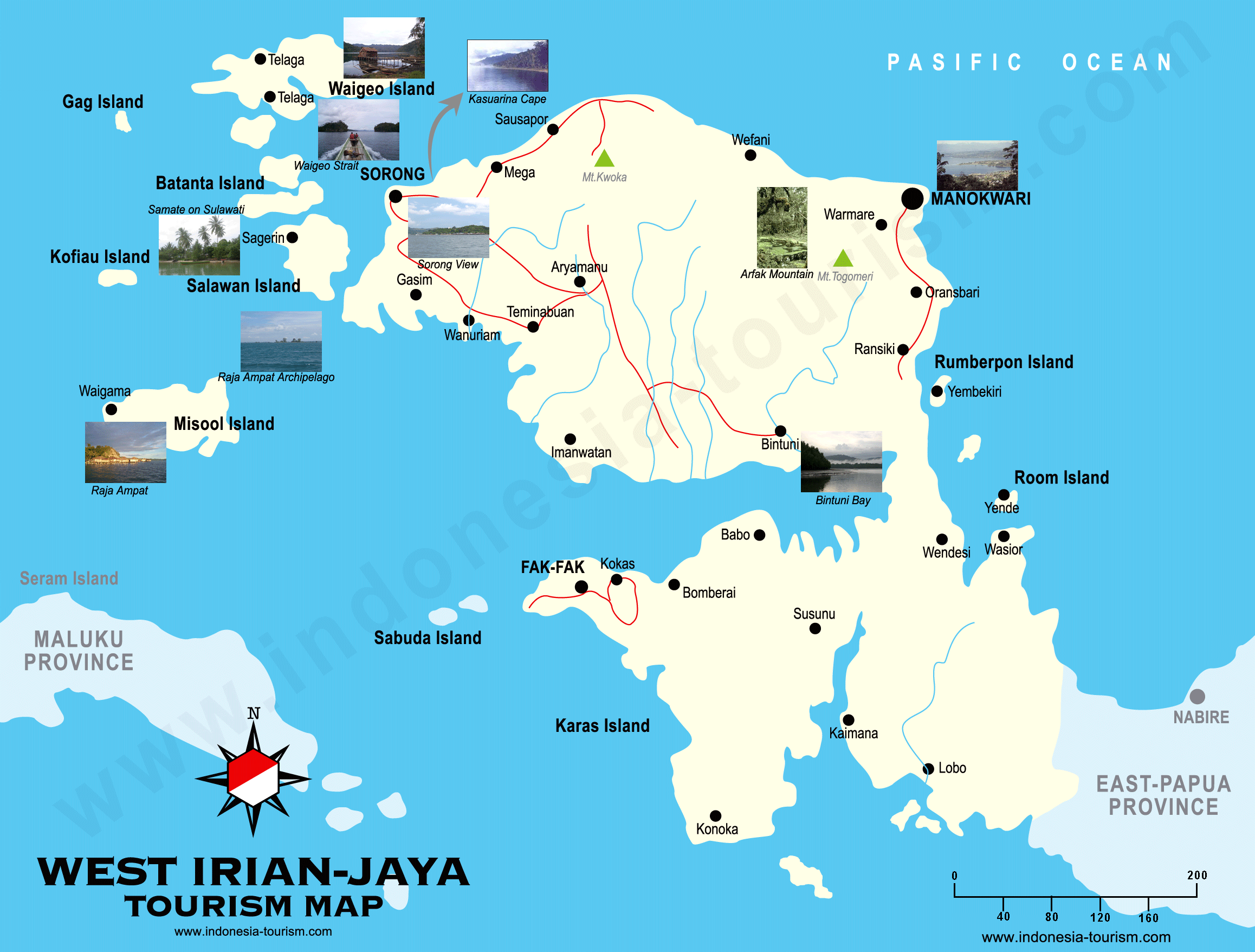
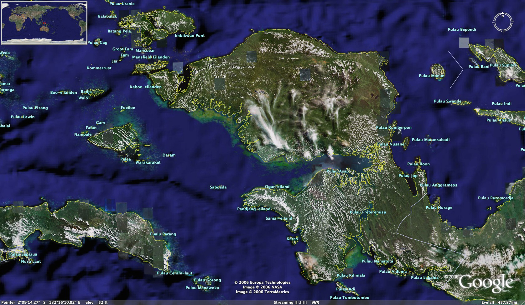
6. West Papua (now ‘Irian Jaya’): West Papua is the most isolated and sparsely populated provinces of Indonesia. See www.westpapuatrekking.com/introduction.html and www.papuaweb.org/dlib/tema/kamoro/muller/tourism-irja.rtf for details, a map at www.indonesia-tourism.com/west-papua/map/west_irian_jaya.png, a satellite map at http://www.indonesia-tourism.com/west-papua/map/west-papua-shigh.jpg and www.westpapuatrekking.com/photosanditineraries.htm for photos. I could not find any signs of canoeing in Irian Jaya apart from natives making a canoe – see www.travelvdo.com/video_irian-jaya-mario-3_356.

Tour Operators, Travel Guides & Consultants
There are a number of rafting tour operators in Indonesia, though I would exhibit care about whom you go with. You need to be concerned about the quality of their training and equipment. Mind you a lot of the concern is a lot of competitive humbug, as the risk depends on the grade of the river. You also need to check out who they are affiliated with since some ‘associations’ are no more than self-appointed chieftains.
1. Jenars Adventurindo, Jalan Raya Tomohon 452, Kakaskasen Dua, Tomohon Utara - 95365, Sulut, Indonesia. Tel/fax: (62-431) 3157154 Email: info@adventurindo.com
2. P.T Korindo Network Lintas Raya Tours and Travel - Jalan Intan 3 Blok D No:14,BTN Bumi Selaparang Asri Belencong,Gunung Sari,Lombok Barat,West Nusa Tenggara(NTB),Indonesia Tel: (62-370) 6649108 Fax: (62-370) 647327 Website: www.korindo-network.com
3. Indonesian Whitewater Federation (Federasi Arung Jeram Indonesia) - see www.faji.org
. Email: pb_faji@faji.org. See the rafting calendar - www.intraftfed.com/competition/calendar.html.
4. Azimuth Adventure Travel Ltd, Jalan Pandega Marta VI/4 - Catur Tunggal, Yogyakarta 55281, Indonesia. Tel: (62-274) 560 663 Fax: (62-274) 560 663. Email: info@azimuth-travel.com
Website: www.azimuth-travel.com/our_trips.php?prog_id=8&lang=eng.
5. Sobek: See www.bali-travel-online.com/bali/white_water_rafting/sobek.htm
.
6. Indosella Expedition: Perumahan Azalea Blok B/15, Panakkukang Mas, Makassar, South Sulawesi, Indonesia. Tel: (62-411) 5073499 Fax: (62-411) 439057, Email: Hernan.Halim@gmail.com
. Website: www.indosella-expedition.com/kayaking.html,
7. Personal guide - T.Y. Johan S. - tour guide for river rafting and mountain trekking - Wisma Cinta Alam - Jln. Blangkereren - Ketambe - 24652 Kec. Badar - Kab. Agara - Aceh Indonesia

Maps of Indonesia & its Provinces
See www.indonesia-tourism.com/map


Other Information Resources:
www.indonesiapromo.com/rafting.html

www.infohub.com/TRAVEL/SIT/sit_pages/8786.html

http://indahnesia.com/indonesia/SUTLAW/bukit_lawang.php

www.indecon.or.id/pdf/Nsumatra.pdf

www.travel-indonesia.com/index.cfm?menuid=30

http://indahnesia.com/indonesia/SEESKA/see_south_kalimantan.php

www.borneoexpress.com/borneo_national_parks.htm

------------------------------------
Andrew Sheldon www.sheldonthinks.com

Rafting the Chico River, Cagayan Province, The Philippines

The Chico River flows east to Tabuk City, before joining the Cagayan River 40km to the north. Tabuk City is easily reached by bus from Tuguegarao City, which provides a flight connection to Manila (PR208). Alternatively you can travel on the Haisema Mountain Highway from Baguio City or the Mountain Polis Highway from Manila. From Tabuk City you can get a jeepney west to Pasil in Kalinga municipality.
There is a 4 hour rafting adventure offered on the Chico River between Pasil and the exit point at Tabuk. The trip covers beautiful scenery such as gorges and waterfalls. The rapids on the Chico River are rated as Grade 2 to 4. After the trip, you can easy get a meal in Tabuk City, and commute back to Tuguegarao City for a flight to Manila (PR237).
Marsman Drysdale Travel Inc organizes rafting adventures on the Chico River from their head office at: 19th Floor Robinsons Summit Center 6783 Ayala Avenue, Makati City, Philippines or visit their website www.marsman-tours.com.ph
. Email: inquiry@marsmandrysdale.com. Telephone: (63-2) 887 0000.

Location Map References for Chico River: See http://maps.google.ca/maps?f=q&hl=en&geocode=&time=&date=&ttype=&q=chico+River+Philippines&sll=15.029686,119.20166&sspn=10.236578,20.43457&ie=UTF8&ll=17.39389,121.294556&spn=0.158242,0.31929&t=h&z=12&om=1
Info about Tabuk City – see http://en.wikipedia.org/wiki/Tabuk_City%2C_Kalinga
-----------------------------------------------
Andrew Sheldon www.sheldonthinks.com

Thursday, May 15, 2008

Canoeing the Mokihinui River, Sth Island, New Zealand

I've got a good idea where I will be going on my next trip to NZ. I've just been reading how the NZ government is about to dam the Mokihinui River on the West Coast of New Zealand. Looking at the YouTube video below, it appears to be a pretty scenic river, with a mix of Grade 1-3 rapids. Though I'm gauging that purely from the river so do your own research. The Mokihinui River is the longest river on the West Coast of NZ, but that’s not saying much since the catchments are small.
I go hate to see river catchments destroyed. This one is fairly scenic. In this case it’s not readily apparent why there is a need for hydro electric power since there is a significant amount of coal in the area. So greenies, you can choice your poison – a coal fired power station or a hydro scheme. Regardless one suspects someone will be making your mind up for you. But at least dissident canoeists can have their chance for a canoe because I dare say government will be debating the issue for another 2 years before construction will prevent canoeing. In the interim here is an idea of what will be lost.
Also, check out the link from the Forest and Bird website: http://www.forestandbird.org.nz/conservation/freshwater/mokihinui.asp where you will ways to help Save the Mokihinui River.

-------------------------------------------------
Andrew Sheldon www.sheldonthinks.com

Tuesday, April 15, 2008

Strategies for a weekend adventure

I think in any city where you are surrounded by nature you want to get away for a weekend at least to escape the city. But that is not enough to preserve your interest. You can relate and read a book by a pool, but then you have probably done plenty of that in your own home city. For something new I have several ideas:
1. You take a weekend and hire a campervan and go tripping. But dont just lounge around. Find that fishing gear that you never seem to use, or borrow a friends, and get yourself a canoe so you can enjoy a new experience.
2. Go horse riding for a weekend. Find one that just doesnt walk you around the paddock but takes you up on the range, perhaps with several days camping, or maybe a shorter trip up an isolated river valley.
3. Go mountain biking through some mountain forest trails

It really doesn't cost a lot these days to participate. You can even use the same helmet for canoeing as for horse riding or mountain biking. There is decent equipment made in China if you know what you need, so there is another saving. You can even buy 2nd hand if cash is scarce. These are all great activities for families as well. All my brothers have been canoeing with me. you can buy a decent canoe for as little as $US75 depending on where you live, mountain bikes $150-175. You dont need the latest & lightest, why not start slow with a 2nd hand product. You xan always find another 'sucker' to pay what you did, unless you are real slow to sell it.

My preference is not to make these adventures a one-off but to perform them on a sub-routine basis. Clearly biking is a great activity that you can perform daily, whereas canoeing and horse riding take too much time away from the other things I do. My intent is to challenge myself in work, relationships, recreation and investment. Always seek new opportunities for a challenge. Of course you can only do one thing at a time. This is not a lesson for some. For others its a revelation. For others still, they talk it, but never seem to find the path. I hope you can find the encouragement and resources on this website to take you there.
---------------------------------------------
Andrew Sheldon www.sheldonthinks.com